Coordinate Transforms Example: Calculating Distances between Two Cities
An example of calculating the positions of cities in cartesian and spherical coordinates.
Boston is located at latitude 42° 21' 30" N and longitude -71°,-3',-37" W (The following use of CityData will not work unless you have an active internet connection)
![]()
![]()
![]()
![]()
![]()
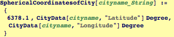
Introduce a function that finds the spherical coordinates of a
![]()
![]()
![]()
![]()
![]()
![]()
![]()
![]()
Minimum travel distance between Boston and Paris for a round earth
![]()
![]()
![]()
![]()
![]()
| Created by Wolfram Mathematica 6.0 (21 September 2007) |